Next time you find yourself driving Southbound on Scott Boulevard in Santa Clara, California – with the Nvidia headquarters behind you – take a moment to look around when you’re on the overpass above the railroad tracks. On the peaks to your East and SSE you’ll see landmarks inviting you to attempt two of the more notable cycling climbs in the area. To the East, past San Jose International Airport, you will spy Lick Observatory on the highest peak in Santa Clara County. Shift your gaze to the SSE and you will spot what locals call “The Cube” at the top of Mount Umunhum.
Riding a bicycle up steep climbs offers a challenge that can provide both mental and emotional benefits. The most obvious physical perks are the excellent cardiovascular workout and ability to build muscle strength. Additionally, many avid cyclists report riding their bike as a form of stress relief. The effort it takes to pedal a bike up steep hills can foster a sense of mindfulness, as individuals line in the moment and become aware of the stress they are putting their body under, as well as their immediate surroundings. Ultimately, the combination of physical exertion and mental clarity cycling can produce a feeling of connection – regardless of the always-on, constant hum of the daily lives in Silicon Valley below.
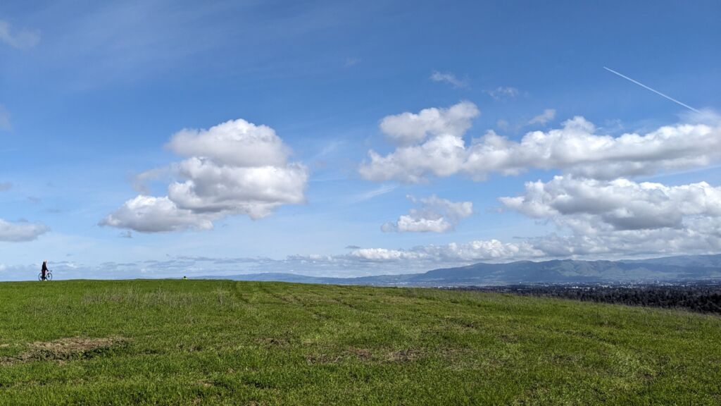
The population centers and work hubs of Silicon Valley have rapidly grown throughout the years. This has led to what many would term a frantic lifestyle and certainly more than a fair share of traffic jams for the over 3 million residents of the area. Despite most of the Valley being paved over, there are roads minutes away where you can get away from it all. And the best way to do that is often on a bicycle. Here are a few select peaks you may want to consider adventuring on if you’re a resident of Silicon Valley or will be visiting soon.

Hawk Hill (San Francisco/Marin County)
2.6 kilometers (1.65 miles) with an average grade of 7%
Strava Verified Ride Segment
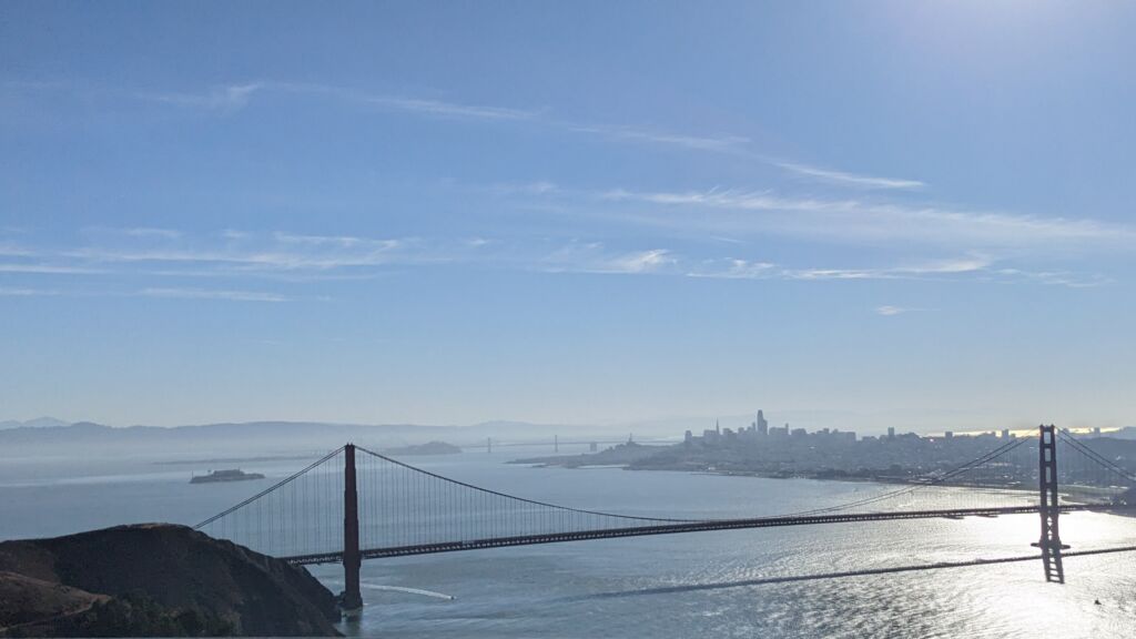
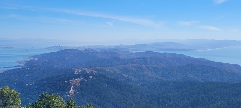
You’ve probably seen photos of San Francisco taken from the top of Hawk Hill and don’t even know it. Whether you drive, bike or hike to the summit of Hawk Hill, your reward will be a breathtaking view of San Francisco with the Golden Gate Bridge in the foreground. If you want to bike there, you are likely to start in San Francisco and ride across the Golden Gate Bridge. Once you do, there will be a small parking lot on the Marin County side. Make an immediate left and you will begin ascending Hawk Hill. The start of the climb will look daunting as you stare up at 400 meters (.2 miles) that averages 10+%. Don’t worry though, things will ease up in the middle of the climb profile before kicking back up just before the lookout area. Along this easier midsection, if you’re not in a rush or trying to get a personal best, you may want to enjoy some additional well-known photo stops such as (starting at the lowest elevation) Battery Spencer, Golden Gate View Point or Golden Gate Observation Deck. All worthy photo-taking locations, but if you ask me, it’s worth it to continue to the summit. Even though the elevation pitches up to about 8% to end your attempt, it’s brief. Enjoy the view, and hopefully it will be a clear day for you.
Before you descend, add some depth to your effort by taking a moment to discover a little World War 2 history. The paved route next to the bathrooms at the lookout area will take you through a concrete portal carved into the mountain. This opening once housed a 153-ton gun put in place to protect San Francisco Bay. As you ride through this short tunnel, below you is a sealed network of tunnels where large munitions were stored. Above you, on top of the mountain, once stood four large domes housing radar equipment. On the other side, you’ll find a grand view of the Pacific Ocean. This was Battery #129.
Mt Hamilton and Lick Observatory (San Jose)
29.2 kilometers (18.2 miles) with an average grade of under 5%
Strava Verified Ride Segment
The saying about riding up to Lick Observatory is “Mt Hamilton won’t blow you up (cycling term for overly exhausting yourself), you’ll blow yourself up on Mt Hamilton.” Okay, it’s my saying, but I’m hoping it will catch on. The angle of the climb up Mt Hamilton road won’t be your greatest challenge as it will mostly fluctuate between 2%-7%. What you will find more challenging is the mental and physical test of your climbing endurance as you (with the exception of two brief downhill sections) face a consistent upward climb that for an average rider will take more than two hours.
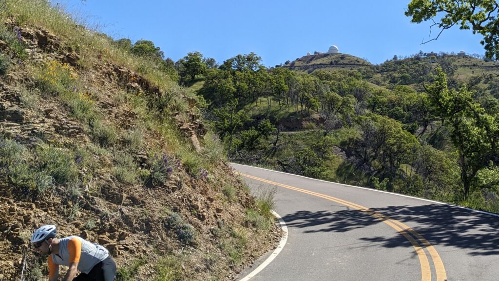
Highway 130, or Mt Hamilton Road, was built in the 1880s in order to construct the observatory at the peak. Given the time period, to transport materials the climb rarely exceeds 7% at any given point in order to accommodate horse-drawn wagons and the pack mules. This provides cyclists today with a long test of their climbing endurance without a steep section that might break your spirit or legs.
Aside from sharing a narrow and winding two-lane road with cars – you will need to worry about water. For such a long climb it’s probably necessary to begin at the base with two or more full water bottles as there is only one guaranteed water stop before the summit. So, whether you need a rest or not, be sure to fill your bottles up at Grant’s Ranch just over 12 kilometers (7.5 miles) from the start of your climb. The water spigot is next to the Ranger’s parking lot toll station on your right. Other than Grant’s Ranch, you will not have reliable access to water until you reach Lick Observatory.
The last 9 kms (6 miles) of Hamilton are the overall steepest section of the climb where the average elevation hits 6%. Six percent isn’t steep to a veteran climber, but it will feel much more daunting after having to climb the previous 19 kms (12 miles) to get there. With your body at least slightly taxed at this point, your mind may begin to falter. This won’t be made easier as the observatory begins to appear to be just around the corner every third or fourth turn all the way to the top.
When you make the last left-hand turn onto the final straightaway and finally see the finish, the mountain doesn’t reward your effort one bit. This straight shot is less than 400 meters (.2 miles), but the average grade of over 8% with a high of 13% and will challenge the fortitude of even the best climber to finish strong.
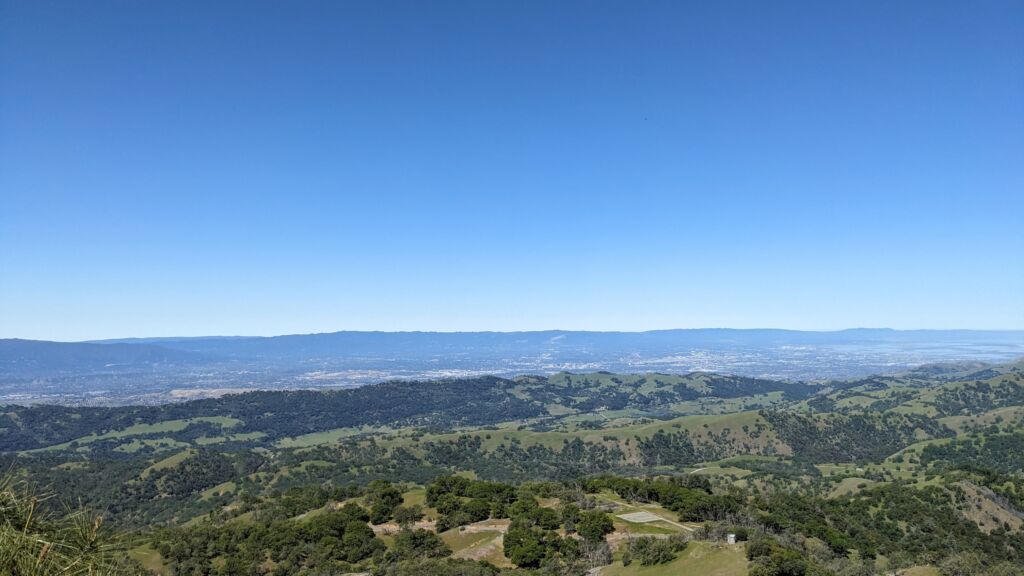
Sadly, there’s one more challenge left after this final dash to end the official segment – and that’s to get to the Observatory itself. I recommend you don’t stop at the vending machine at the summit to rest. Instead, continue non-stop by making a quick hairpin to your right and ride up the narrow, pothole pockmarked road up to the observatory itself. The finale of your climb is an additional 400 meters away, but it’s the first half that will be irritating. The first 200 meters will fluctuate between 6% and 11% before flattening out to a level parking lot with grand views of Silicon Valley below you to your left. Keep circling the building to your right and you will find a small lobby with bike racks outside and a cold water fountain and bathrooms inside. Cyclists are welcomed.
Tips:
– Locals recommend making sure to bring crisp dollar bills to deal with the finicky vending machines at the summit. Additionally, as our IT departments have taught us over the years, feel free to unplug the machines and plug them back in to reset them if your bills are rejected. Maybe it’ll help. Maybe it won’t.
– If you descend the same way you rode up to the summit, you will be descending for over an hour on the mountainside of the road. So on the way up, take note of how many (usually very) small rock slides you see in the downhill lane so you can keep an eye out for them on the way down.
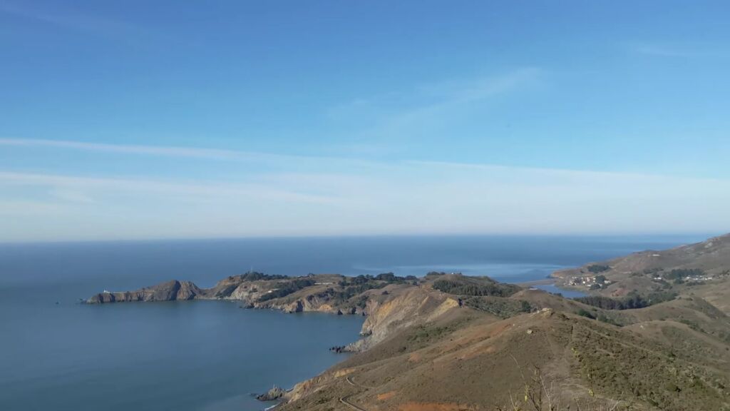
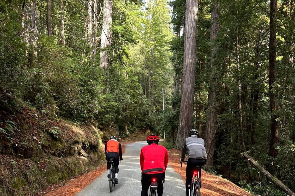
The Bike Hut (Half Moon Bay)
The Santa Cruz mountain range separates the West side of Silicon Valley from the Pacific Ocean. Climbing the roads up and over this mountain range vary from difficult to very difficult. But the rewards for most of them are epic climbing challenges – and many are shaded by tall redwood trees. Whether you’re cycling up these hills alone or with a group, much of these climbs will be accomplished in quiet isolation. Going South to North, some of the most common routes to climb out of the valley and to the ridge of the mountain range before descending to the coast are: Highway 9, Page Mill Road, Old La Honda Road, Kings Mountain and Highway 92.
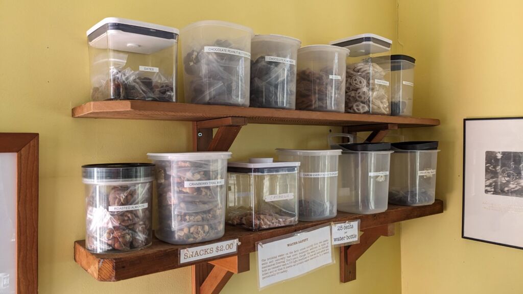
When you embark on these longer rides, it can help to have a goal on the other side of the hill. While there are many scenic destinations you can aim for, there is a cycling-centric beacon just one kilometer from the beach. On Tunitas Creek Road, between Half Moon Bay and San Gregorio, you’ll find The Bike Hut.
The Bike Hut is a cycling oasis that is open 24 hours a day, every day of the year. From the outside it appears to be a small red, wooden building with white trim. But to any cyclist passing by, it’s a pleasant place to rest. It has bike racks, a picnic area outside, bathrooms and a bike work stand. Inside, you’ll find maps, a message board, bike tools, couches, coffee, water and snacks that are replenished daily. One of the more dulcet aspects of the Bike Hut is that all of this is available for payment or donation on the honor system. There are QR codes to donate or make payments, or you can leave cash in the metal cash box on the counter.
Montebello (Cupertino)
8.25 kilometers (5.13 miles) with an average grade of 7.4%
Strava Verified Segment
If you’ve heard of the famous Alpine climb in Southeastern France called Alpe d’Huez, this is Silicon Valley’s version of that climb (minus the altitude of course). Alpe d’Huez is notably more difficult, but the two climbs share unique and challenging profiles. While Montebello is 5.5 kms shorter than its more famous comparison, the first 20% of both rides are the steepest sections and will immediately test anyone who tries to make the ascent. On Montebello, the first 1.5 km (1 mile) will average an unrelenting 9.7% average grade before the next 1.5 kms eases off to a mere 8.5%. Once you’ve survived the most epic challenge the climb has to offer, like on Alpe d’Huez, the middle fifth of the climb flattens out to allow a rest before you complete the task at hand.
The final 3.5 kms of Montebello will average over 8% with only a few relaxed sections – but it will seem easier compared to the beginning of the climb you already survived. The summit is marked by a gate where the paved road ends and the dirt fire trail begins. This is where road cyclists take in the fabulous view that stretches from Gilroy to the South to Redwood City to the North before descending. However, those with a gravel bike have the option to continue past the fire gate on the dirt trail to Page Mill Road in Palo Alto.
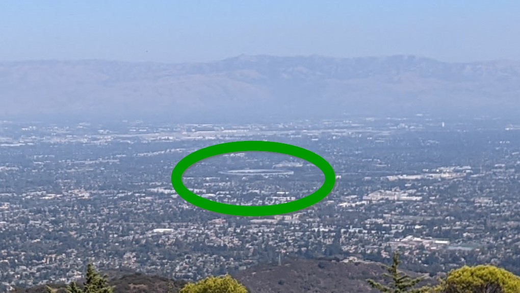
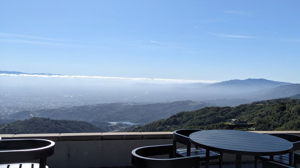
On your way down, you can take in a little wine history just over one kilometer (1 mile) below the summit. In the famous 1976 Judgement of Paris that put California wines on the international wine map, the Ridge Vineyards Monte Bello Cabernet Sauvignon finished fifth overall in the red wine category. Today, from the elevated tasting area at the winery, you can have a masterful view of the heart of Silicon Valley below and look directly down at the circular Apple headquarters. Also, it’s an excellent place to refill your water bottles as the filtered water dispenser is immediately on your left when you enter the tasting room.
Mt Tam/The Pole (Marin County)
Another elevated and epic view of San Francisco can be achieved by climbing Mt Tamalpais in Marin County. Mt Tamalpais is the highest peak in the Marin Hills, just North of Muir Woods. As such, it is a lush forested area with narrow and winding mountain roads. Not all of the roads are in great condition, but given the rustic setting and the challenging effort, most cyclists will be putting in – you may not even notice how unkept some of the roads are.
Whether you are attempting to summit the West or East Peak of Mt Tamalpais doesn’t make much of a difference. The peaks are less than 2 kms apart and at relatively the same height. Best of all, each has a variety of approaches you can choose to route your way to their summit. Personally, I think the more scenic and challenging route begins in Fairfax to the North of Mt Tam. This will add some challenging climbs before you finish on Tamalpais. First, you will ascend to Alpine Reservoir, before beginning a challenging journey up from the reservoir to the ill-named junction at Ridgecrest Boulevard (sorry, but this “boulevard” is often not wide enough for two vehicles).
Once you make this 3.5 km climb with an average grade of 7.2% you will be deep in the shade of redwood trees before eventually emerging on a rolling mountain road that opens to non-stop, grand views of the Pacific Ocean to your right. These undulations are known as The Seven Sisters and, well, quite frankly they are a never-ending pain until you reach the base of Mt Tamalpais.
In this scenario, the actual climb to the top of the West Peak of Mt Tam will not be the most challenging you’ve ridden since leaving Fairfax – but it certainly isn’t easy. The road will be narrow and shaded at the start, but when the trees recede, the grade steepens intensely. This is how your ride will end if you choose to stop at The Pole to add your selfie with San Francisco in the distance behind you to Instagram. If you choose to continue to the East Peak, it is initially double-digit grade steep, but it will flatten out eventually.
Tips:
– If you start in Fairfax, at the base of the climb out of town is a drinking fountain at Town Hall just prior to a 7-11. This is the last place you are guaranteed to fill your water bottle before a long and not always shaded climb.
Travel Trivia: The Mount Tamalpais area is considered by some as the birthplace of modern day mountain biking – as pioneer mountain bike frame builders Tom Ritchey, Gary Fisher and Joe Breeze were all locals who utilized the abundance of dirt trails and fire roads in the area.
Mount Umunhum (Los Gatos)
6.58 kilometers (4.09 miles) with an average grade of almost 9%
Strava Segment
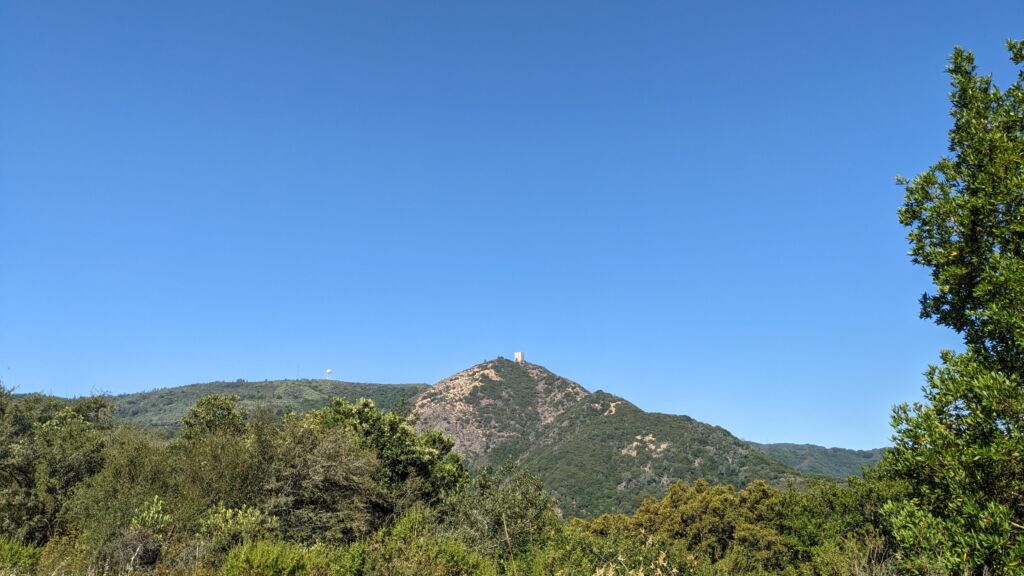
Atop the Southernmost part of the Santa Cruz mountains in the town of Los Gatos sits an odd-shaped building the locals refer to as “The Cube.” This perfectly square, 5-story high concrete former radio tower can be seen from all directions. Abandoned since the 1980s this building and its small parking lot attracts hikers and cyclists regularly.
The final climb to The Cube begins at Jacques Ridge at the intersection of Hicks Road and Mt Umunhum Road. But this isn’t the hardest part of riding up to The Cube. First you have to climb what is referred to as Upper Hicks Road and that is where you will find your climbing abilities tested the most. After ascending the 8 kms (5 miles) of Lower Hicks Road, you will immediately make a sharp u-turn onto the beginning of Upper Hicks. Upper Hicks is a short and brutal climb that measures 2 kms (1.25 miles) with an average grade of 11.3%. Not only does this climb rarely relax below 6% – it will peak at 20% multiple times. Worst of all, the first kilometer is the most callous as it averages over 12%. Don’t waste your climbing energy on Lower Hicks. Take your time getting to Upper Hicks – you’ll need the legs for it.
When you make your way to the start of Mt Umunhum Road the hardest climbing may be behind you, but the last 6 kilometers up this winding road won’t seem easy. This section of the climb will rarely relent and also throw in brief and steep challenges for you. You may even be too exhausted to take in the wonderful views of the small valley you are in that is part of the Sierra Azul Open Space Preserve. But if you carry on to the summit, you will have stunning views from the Pacific Ocean on one side, back to Santa Clara County on the other.
Tips:
– there is no water available when riding up Hicks Road from the Camden Ave or Shannon Road side of the mountain. So have your bottles full before you begin and try this climbing challenge early in the morning or on a cooler day. You are exposed to the elements most of the climb up Mt Umunhum Road
– What climbs up, must ride down. After the rapid descent down Mt Umunhum Road, regardless of which side of Hicks Road you choose to descend from there, use a lot of caution. Both are steep and there are a lot of blind turns that will reveal fast moving cars heading up the hill.
Hellyer County Park Velodrome (San Jose)
Not exactly a mountain climb or even the style of bike you may be used to, San Jose is home to the only velodrome in Northern California. The Hellyer Park Velodrome was built in the 1960s and has since hosted the US team qualifying events for the Olympic games. As such, the oval is Olympic regulation at 335 meters per lap with 23-degree banked turns.
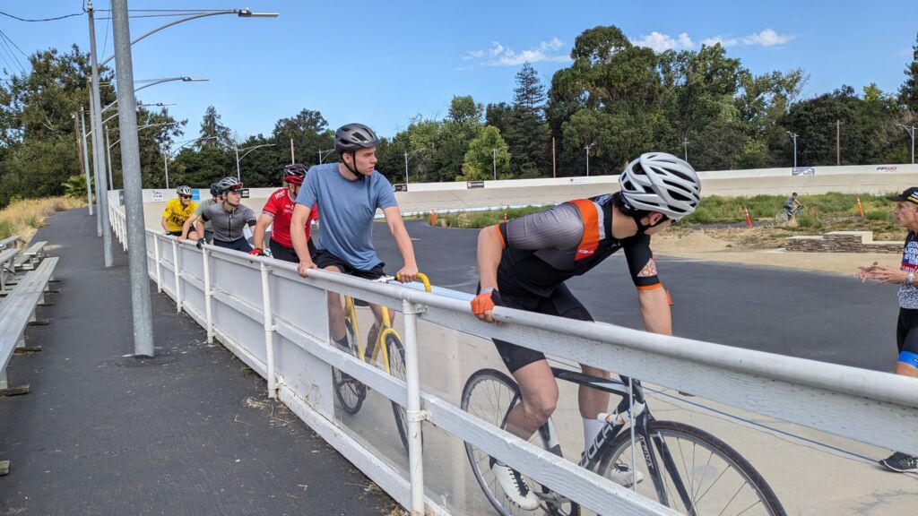
Today, this open air velodrome is administered by the Northern California Velodrome Association, a non-profit, dedicated to keeping the velodrome an affordable and fun option for cyclists and families in the surrounding area. Among other events, most Saturdays, the velodrome will host beginner classes that, for a small fee, include track bike rental for those looking to try track cycling. Riders under the age of 18 are typically invited to train and race for free.
In Silicon Valley, the cycling community, culture and spirit can provide a chance to be in the moment and counterbalance the hectic life that surrounds you. Cycling some of the more notable climbs in the area can provide a cyclist with a sense of connection in what may otherwise seem like an estranged area. So, if the daily grind of working in Silicon Valley ever gets to be too much for you, or your touristy plans involve more than concrete and code – consider one of these climbing adventures. You’ll work hard to ascend these summits, but the exercise and introspection will often lead to sensational views.
To paraphrase the Scott McKenzie song “San Francisco”: If you’re going to Silicon Valley, you’re going to want to bring your bike there.
Have you ever traveled for the purpose of cycling or another sport? Or what are some of your favorite places to ride that aren’t in your home area?